
Folded Map: Charleston Street Map (Rand Mcnally)

Product Description
Condition - Very Good
The item shows wear from consistent use but remains in good condition. It may arrive with damaged packaging or be repackaged.
Folded Map: Charleston Street Map (Rand Mcnally)
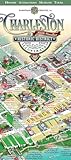
Rand McNally's folded map for Charleston is a must-have for anyone traveling in and around this part of South Carolina, offering unbeatable accuracy and reliability at a great price. Our trusted cartography shows all Interstate, U.S., state, and county highways, along with clearly indicated parks, points of interest, airports, county boundaries, and streets. The easy-to-use legend and detailed index make for quick and easy location of destinations. You'll see why Rand McNally folded maps have been the trusted standard for years.
Folded map features:
Regularly updated
Full-color maps
Clearly labeled Interstate, U.S., state, and county highways
Indications of parks, points of interest, airports, county boundaries, schools, shopping malls, downtown & vicinity maps
Easy-to-use legend
Detailed & full street index
Convenient folded size
Communities Included: Goose Creek, Hanahan, Isle of Palms, Lincolnville, Mount Pleasant, North Charleston, Sullivan's Island, Summerville plus downtown enlargement
Technical Specifications
You might also like
Charleston Historic District Illustrated Map

Easy To Read: South Carolina

Streetwise Charleston Map - Laminated City Center Street Map of Charleston, South Carolina (Michelin Streetwise Maps)

Fodor's In Focus Charleston: with Hilton Head & the Lowcountry (Travel Guide)

The Best Little Map of Charleston, S.C.

Easy To Read: Georgia State Map (Rand McNally Easy to Read!)

Wildsam Field Guides: Charleston (American City Guide Series)

Rand McNally Folded Map: Charlotte Street Map

Charleston: A Historic Walking Tour (Images of America)

Folded Map-Savannah & Hilton Head Island