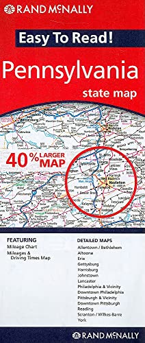
Easy To Read: Pennsylvania State Map
Product ID: 0528882015
Condition: USED (All books in used condition)
Sold Out
Product Description
Condition - Very Good
The item shows wear from consistent use but remains in good condition. It may arrive with damaged packaging or be repackaged.
Easy To Read: Pennsylvania State Map
- shows all Interstate, U.S., state, and county highways
- clearly indicates parks, points of interest, airports, county boundaries, and streets
- easy-to-use legend and detailed index make for quick and easy location of destinations
Technical Specifications
Country
USA
Brand
Rand McNally
Manufacturer
Rand McNally
Binding
Map
ItemPartNumber
Illustrated
UnitCount
1
Format
Folded Map
UPCs
070609882017
EANs
9780528882012
You might also like
The Fantastic Art of Frank Frazetta
The Cultural Revolution: A Very Short Introduction

Darwin: A Very Short Introduction

Politics: A Very Short Introduction

Muhammad: A Very Short Introduction

The British Empire: A Very Short Introduction

The Tudors: A Very Short Introduction

Newton: A Very Short Introduction